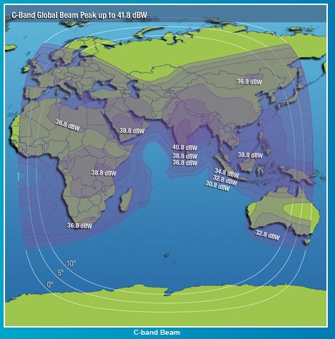
The area of the Earth covered by the microwave radiation from a satellite dish (transponder) is called the satellites footprint. The size of the footprint depends on the location of the satellite in its orbit, the shape and size of beam produced by its transponder and the distance from the earth. The footprint can be seen as:
- The area in which a broadcast signal from a particular satellite can be received
- The area on the surface of the earth within a satellite’s transponder (transmitter or sensor) field of view.

There are usually different maps for each transponder (or group of transponders) as each may be aimed to cover different areas on the ground. The maps usually show either
- the estimated minimal dish diameter required or
- the signal strength in each area measured in dBW. dBW (decibel watt) is a standard unit of measurement of the strength of a signal expressed in decibels relative to one watt.
Limitations
Maps show general coverage for regions and therefore any boundary as indicated by the footprint maps, should not be interpreted as a rigid limit. The quality of reception can be very at different places short distances apart. This occurrence is more noticeable as the frequencies increases.
The difference between high and low frequencies are:
- Low frequency
- can travel around the world
- has low energy power
- needs a bigger dish
- minimal interference by clouds
- High frequency
- are mostly straight line of sight
- have a lot of energy power
- scatters very easy into different directions (by severe storms)
- needs a smaller dish
Follow this link for the footprints of a few satellites.


how do i connect my astrovox receiver to intelsat 10 68.5 degrees to view emmanuel tv hope channel
I’m looking for a step by step guide on how to view more channels on my dsd 1110. I’m from south africa.thanx